North Umpqua Wild and Scenic River
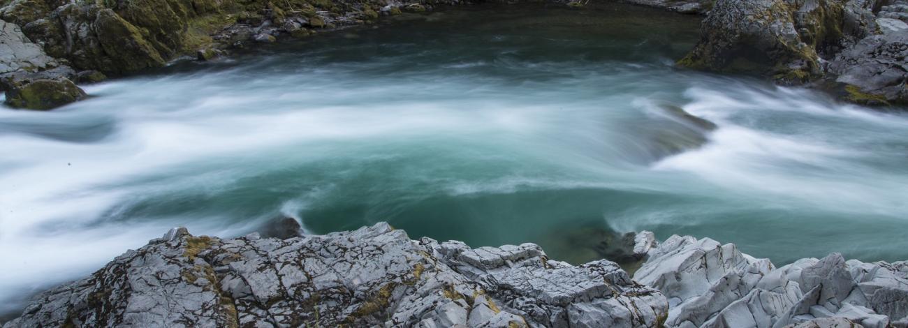
Renowned for outstanding salmon and steelhead fishing and exhilarating whitewater, the North Umpqua provides river running opportunities for paddlers of all skill levels, from placid waters to roaring rapids. The combination of large summer run steelhead, fly-fishing only restrictions and majestic scenery has drawn anglers from all over the world. This truly distinctive canyon landscape is characterized by a combination of clear, jade green rushing water, vertical rock cliffs and spires within a mosaic of mountain meadows and hemlock forests.
- Designation and Management
-
Designation Type and Date: Recreational; October 28, 1988
Length: 33.8 miles
Management Responsibilities: Roseburg BLM 8.4 miles, Umpqua National Forest 25.4 miles
- Outstandingly Remarkable Values
-
Fisheries: The combination of large summer run steelhead, fly-fishing only restrictions and majestic scenery has drawn anglers from all over the world. The river serves as needed habitat for a variety of resident and anadromous fish species, including summer and winter steelhead, fall and spring chinook, coho sea-run and cutthroat trout, and is distinguished from other rivers by the large and consistent numbers of native (non-hatchery) fish in the run. The North Umpqua summer steelhead fishery is considered one of the most outstanding on the West Coast.
Recreational: Renowned for outstanding salmon and steelhead fishing and exhilarating whitewater, the North Umpqua provides river running opportunities for paddlers of all skill levels, from placid waters to roaring rapids. The best months for enjoying whitewater are May, June and July. The 79-mile long North Umpqua Trail parallels the river and offers visitors challenging hiking and mountain biking experiences.
The area is readily accessible to a broad segment of the population and provides a variety of river-related recreation, such as boating activities, fly angling, developed and dispersed camping, day use picnicking and swimming, horseback riding, hiking, sightseeing, bicycling, photography, nature study and scenic driving. Oregon State Highway 138, the main corridor route, is a National and Oregon State Scenic Byway and serves as a primary access to Diamond Lake Recreation Area and Crater Lake National Park. Visitors from over the world travel through the North Umpqua River corridor to enjoy these major destination attractions.
Scenic: This truly distinctive canyon landscape characterized by a combination of clear, jade green rushing water, vertical rock cliffs and spires within a mosaic of mountain meadows and hemlock forests. Adding to the natural scenic quality of the North Umpqua River corridor are the locations of numerous prominent geologic features of columnar basalt, large basalt rock boulders and spires currently managed as the Umpqua Rocks Special Geologic Area. Few river systems in the region expose as much of the volcanic and geologic history of the formation of the Cascades in one straight, east-west direction.
Cultural: Radiocarbon dating places prehistoric occupation of the North Umpqua River as early as 6,300 years ago, and the presence of the time-sensitive artifacts indicates the occupation may go as far back as 8,000 years. This long period of occupation resulted in the formation of a number of sites within the river corridor that have unusual characteristics when compared with other sites in the region.
Visitors were initially drawn to the Steamboat area within the North Umpqua River corridor because of the excellent fishing. The first known fish camp constructed on the river in the 1920s was located in this vicinity. Also found in this area is Mott Bridge, an Oregon Historical Civil Engineering Landmark. Constructed by the Civilian Conservation Corps in 1935-36, it may be the only surviving example of three such structures from that time in the Pacific Northwest.
Water Quality and Quantity: The North Umpqua River sustains a dependable water flow of both high quality and quantity. Components that combine to produce the high water quality are low turbidity (except during peak flow periods), low levels of contaminants and pollutants, cool water temperatures and stable minimum instream flows. The water quality and quantity of the North Umpqua River is the foundation for the other outstandingly remarkable values, providing a steady flow for both recreational uses and the maintenance of fish and aquatic life.
- Recreation - Aquatic
-
Swimming
Anywhere, though use caution, as the North Umpqua River is cold. Average water temperature in summer is mid to upper 50s.
Boating
- Primary boating types are rafts and kayaks. Closed to motorized use. Drift boats not recommended.
- Known as a class III river though there is one class IV (Pinball) and one class V (Deadline Falls). There are over 40 named rapids.
- Best months to boat are May – July.
- River is broken into five segments:
- Segment 1 (USFS) – Boulder Flat to Horseshoe Bend. Access at Boulder Flat CG and Horseshoe Bend CG.
- Segment 2 (USFS) – Horseshoe Bend to Gravel Bin. Access at the Gravel Bin put-in/take-out – mile 39.7.
- Segment 3 (USFS) – Gravel Bin to Bogus Creek. Access across Highway 138 from the Bogus Creek CG – mile 35.
- Segment 4 (USFS/BLM) – Bogus Creek to Susan Creek. Access at Susan Creek DUA – mile 28.7.
- Segment 5 (BLM) – Susan Creek to Cable Crossing. Access at unsigned gravel road leading to take-out – mile 23.4.
- Amenities at all of the launch sites include parking, restrooms, picnic tables, and river information panels. Boulder Flat and Gravel Bin have changing stations. Guidelines: in order to reduce potential conflicts between boaters and anglers it is recommended that boaters avoid boating before 10am and after 6pm, and to avoid boating Segment 3 after July 15.
- No parking or day-use fees anywhere along the river. Permits or registration not required.
- Currently there are seven outfitter/guides to conduct river running trips. There are no equipment rental business along the North Umpqua.
- Recreation - Land
-
Mileages are from Roseburg on Highway 138, traveling east.
Day Use Areas
- Swiftwater Day-Use Area, Mile 21.9
- Baker Wayside, Mile 23.8
- Susan Creek Day-Use, Mile 28.5
Information/Interpretation/Education
- Colliding Rivers Exploration Station; Mile 16.4. Located on the grounds of the North Umpqua Ranger Station. Constructed in 1938 by the Civilian Conservation Corps. Interpretive displays, brochures, maps, books, refreshments. Operated by the Douglas County Museum Foundation through a partnership with the Umpqua National Forest and BLM Roseburg District.
Camping/Overnight
- There are some designated dispersed camping sites within the corridor, both on USFS lands at Wright Creek and Williams Creek. Otherwise, dispersed camping is discouraged within the corridor.
- Camping (BLM segment)
- Susan Creek Campground (mile 29.5) - Generally open mid-April through late October. $20/site, extra vehicles $5. Mix of first come-first served and reservable sites. Reservable sites available for reservations mid-May – mid-September. Flush restrooms, showers, horseshoe pits, amphitheater for weekend BLM specialist chats June – August.
- Within 5 miles of the corridor: Millpond Campground with reservable day-use pavilion, Rock Creek Campground also with reservable day-use pavilion, and Scaredman Campground. Reservable group camping available at Lone Pine Group Campground.
- Camping (USFS segment)
- Mix of first come-first served campgrounds at Bogus Creek, Canton Creek, Island, Apple Creek, Horseshoe Bend, Eagle Rock, and Boulder Flat. Group camping available at Deer Flat and Steamboat Ballfield.
- Overnight lodging available at the Dogwood Motel (mile 26), Steamboat Inn (mile 39), and Umpqua’s Last Resort (mile 47.5)
Hiking Trails
- The 79-mile long, National Recreation Trail – North Umpqua Trail runs parallel to North Umpqua River through the entire WSR corridor. The NUT is designated as an International Mountain Biking Association "Epic Ride," one of only a few in the entire world. Trail broken up into seven segments along the WSR corridor. BLM Segments – Swiftwater 7.8 miles and Tioga 3.7 miles (Tioga segment continues for another 4.3 miles on the FS). Tioga segment begins at the 220' long pedestrian Tioga Bridge constructed by BLM in 2012. USFS segments: Mott 5.5 miles, Panther 5 miles, Calf 3.7 miles, Marsters 3.6 miles, and Jessie Wright 4.1 miles. Each segment has its own trailhead with parking, restrooms and interpretive panels. Trail continues for 41.5 more miles, eventually ending at the Pacific Crest Trail.
- Other BLM trails include the 1-mile long Emerald Trail, connecting the Tioga Bridge with Susan Creek Day-Use Area and Susan Creek Campground and the 0.8-mile long Susan Creek Falls Trail leading to the 50' tall Susan Creek Falls. Trailhead at Susan Creek DUA.
- USFS trails of note in the corridor:
- Fall Creek Falls: 1 mile in length, trailhead at mile 32.7.
- Riverview Trail: 6 miles in length and follows original Highway 138. Connects Bogus Creek Campground with the Mott Trailhead on the north side of the river and highway (NUT on south side of river and highway).
- Boulder Creek Trail: Trailhead at Soda Springs (end of WSR corridor). Accesses the Boulder Creek Wilderness.
- All trails in corridor are non-motorized. Hiking, Biking, Equestrian OK.
- Currently there are 3 permitted outfitter/guides to conduct mountain biking excursions on the NUT. There are also 2 permitted long distance (a 50k and a 100k) running races on the NUT.
Scenic Driving/Cycling
- Highway 138 primary route through the corridor is a National Scenic Byway and the Rogue-Umpqua State Scenic Byway. It is not a Scenic Bikeway.
Fishing
- Access – Numerous turnouts along Highway 138, the NUT, campgrounds, DUAs. No shortage of access.
- Platforms – One located at Swiftwater DUA.
- Fish Species – Summer and winter steelhead, fall and spring chinook, coho sea-run and cutthroat trout are the most popular.
- Regulations – fly-fishing only the entire length of the WSR. Fishing from any type of watercraft is prohibited. See ODFW fishing regulations for further info.
- Currently there are 10 outfitter/guides permitted to conduct guided fly-fishing trips.

