
Douglas Point Special Recreation Management Area
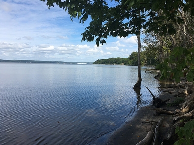
The Douglas Point Special Recreation Management Area (SRMA) in Charles County, Maryland, offers fantastic opportunities for hiking, horseback riding, hunting, fossil collecting, and relaxing along the shore. Located near fast-paced Washington, D.C., it is one of the last remaining undeveloped tracts along the Potomac River. Douglas Point encompasses 548 acres of hardwood forest and marshes, a picnic area overlook, river shoreline, an accessible historical walk, and hunting blinds.
On December 21, 2001, BLM and the State of Maryland jointly acquired about 1,270 acres of land known as Douglas Point, lying on the east side of the Potomac River. Douglas Point is part of the Nanjemoy Natural Resource Management Area (NRMA) which is jointly managed by the BLM and the Maryland Department of Natural Resources (MDNR). The management of this property offers a unique opportunity for federal, state, and local agencies to work together in a seamless effort with the public to both protect the quality resources in this area for generations to come, and to allow compatible passive recreational use of these public lands.
The Douglas Point tract contains magnificent hardwood forests, historic houses, and scenic views. Douglas Point is one of the most ecologically and culturally significant landscapes in the State of Maryland. The area’s outstanding natural attributes are equally matched by its archeological resources and history, including early American Indian sites, remnants from the Civil War, ruins of the colonial-era Chiles homesite, as well as dozens of World War I-era sunken ships, which now lie in Mallows Bay.
Photos
Accessibility Description (ABA/ADA)
There are 2 packed gravel parking areas in the Douglas Point SRMA. The North Trailhead lot has 1 designated accessible parking space with 5 other parking spots, although the entire lot should be suitable for people with mobility devices. The South Trailhead lot has 5 parking spots. None of them are designated for accessible parking but this lot should also be suitable for mobility device users.
The South Trailhead parking lot is next to the accessible Chiles Homesite Trail, which takes visitors 1/3 mile to the historic homesite. This gravel trail is relatively flat, 5 feet wide, and has interpretive panels and 1 bench near the Homesite. At the Homesite, visitors can continue north on the Cal Posey Trail 1 mile to the North Trailhead parking lot or go back to the South Trailhead parking lot. The Cal Posey Trail is “easy” but wasn’t built to be accessible.
Both the accessible Chiles Homesite Trail and the Cal Posey Trail are designated as multi-use (hiking, mountain biking, and equestrian) and are part of the Potomac Heritage National Scenic Trail.
The other trail at the site, not built to be accessible, is the 1/2-mile “easy” Blue Banks Beach Trail, which leads from the Cal Posey Trail to the Blue Bay Beach.
There are no restrooms or potable water at Douglas Point.
NOTE: Descriptions and photos uploaded January 2025. Please note that actual on-the-ground conditions may vary due to natural events (e.g., weather, wildfires, erosion), normal wear and tear, or site improvements.

Phone
Activities


Addresses
Geographic Coordinates
Directions
Douglas Point has two parking lots, North Trailhead and South Trailhead. The two parking lots are about 1 mile apart and are connected by Cal Posey Trail.
From Interstate Highway 95/495 in Maryland: Take Exit 3 for Hwy 210 South to Hwy 225, connecting with Hwy 224. Take 224 for about 14 miles. You should see signs for Nanjemoy and the Purse State Park. The parking lot is on the right side.
From US-301 N: Turn left onto MD-6 (Port Tabacco Rd). Take MD-6 for about 15 miles. Turn right onto Greenleek Hill Rd and in 0.2 miles keep right to continue on Greenleek Hill/ Jacksontown Rd for 2.3 miles. At the end of the road take a right onto Liverpool Point Rd and at the stop sign (400 feet ahead) take a left on MD-224 S. The parking lot will be on the right in 1 mile.
Trailhead Address:
North Trailhead – 9275 Riverside Rd, Nanjemoy, MD
Chiles Homesite Trailhead – 9699 Riverside Rd, Nanjemoy, MD
Fees
No fees